Lake Winnipeg: The Third Largest Lake Located Entirely In Canada
Lake Winnipeg is located on the boundary between the low-relief Inferior Plains and the southwestern Canadian Shield. It is the eleventh largest freshwater lake in the world and the third largest lake located entirely in Canada. It also boasts the second largest watershed in the country.
Lake Winnipeg Stats
| Lake Name | Lake Winnipeg |
| Country | Canada |
| Surface area | 23923.040 |
| Maximum depth | 36.0 |
| Average depth | 11.9 |
| Lake type | Reservoir |
| Length | 416.000 |
| Width | 100.000 |
| Catchment area | 919611.50 |
| Altitude | 215.0 |
| Volume | 284.000 |
| Inflows | Winnipeg River, Saskatchewan River, Red River |
| Outflows | Nelson River |
| Shore length | 4018.32 |
| Settlements | Gimli, Manitoba |
| Residence time | 1464.3 |
| Frozen | November to March |
| Origin | Glacial |
| Average discharge | 2244.727 |
Geography
Lake Winnipeg is located in central North America, in Manitoba, with its southern end situated merely 55 kilometers north of Winnipeg. It’s the largest lake in Southern Canada, in the most underdeveloped watershed in the country. It has an essential role in local tourism, recreation, commercial and sport fisheries, as well as hydroelectric generation in Manitoba. Winnipeg and Manitoba lakes are remains of the prehistoric Lake Agassiz. The area between the two is called the Interlake Region, whilst the whole region is called the Manitoba Lowlands.
The lake’s drainage basin is home to 7 million people. Numerous communities can be found on its shores, such as Grand Beach, Lester Beach, Riverton, Winnipeg Beach, Victoria Beach and Pine Falls. The lake’s many bays and harbors lengthen the coastline, making it 1750 kilometers long in total.
Lake Winnipeg can be separated into a larger, deeper Northern basin and a smaller, shallower Southern basin. The eastern side is bordered by pristine boreal forests and rivers, making it a potential candidate for a United Nations World Heritage Park. Its coastline is mostly made up of remote sand beaches, large limestone cliffs and is dotted with numerous bat caves. The Manitoba Hydro uses Lake Winnipeg as one of the largest reservoirs in the World.
Hydrology
The lake’s watershed occupies 982 900 km2, with Alberta, Saskatchewan, Manitoba, northwestern part of Ontario, Minnesota and South Dakota. Its drainage system is 40 times larger than the lake’s surface, making it the largest in the World. Because of this massive watershed next to a small water volume, the lake is easily dominated by events in its watershed. Since the lake is relatively shallow, its water column isn’t stratified, so the bottom waters only differ in 1-2OC from the top layer.
The lake has numerous tributaries, of which three are larger. The Saskatchewan River flows from the west through Cedar Lake. The Red River flows in from the south whilst the Winnipeg River enters from the southeast, draining the Lakes of the Woods, Rainy River, and Rainy Lake). These three make up 60% of the lake’s waters. Other inflows are the Poplar, Berens, Pigeon, Dauphin, Fisher rivers. The Dauphin River enters from the west draining Lake Manitoba and Lake Winnipegosis. The Bloodvein River, Berens River, Poplar River and Manigotagan River flow in from the east, within the Canadian Shield.
The lake’s main outflow is the Nelson River, regulated for hydroelectric power since 1976, making Lake Winnipeg the third largest hydroelectric reservoir in the World. It forms part of the Hudson watershed, one of the largest in the World. This area used to be known as Rupert’s Land when the Hudson’s Bay Company was chartered in 1670.
Ecology and Threats
Lake Winnipeg is an important site for commercial fisheries. Its catches make up the major part of Manitoba’s $30 million a-year fishing industry. It was once the main source of the goldeye in the country, which is why the fish is often referred to as the “Winnipeg goldeye”. The common carp was introduced through the Red River. Walleye and whitefish make up more than 90% of the lake’s commercial fish.
Recently there has been an explosion in the algae population, caused by excessive amounts of phosphorous seeping into the lake, which because of this isn’t getting enough nitrogen. The phosphorous concentration is three times higher in the southern basin than in the northern. Nitrogen concentration is slightly higher in the south. 6 aquatic invasive species thrive in the lake: the common carp, rainbow smelt, white bass, spiny water flea, the Asian tapeworm and the cladoceran Eusbomina coragoni. Because of the nutrient increase of the ‘90s the phytoplankton biomass has doubled. Phosphorous levels are reaching a point where the lake becomes dangerous for human health. The Global Nature Find declared Lake Winnipeg as “threatened lake of the year” in 2013.
Transportation on Lake Winnipeg
Because of its length Lake Winnipeg and its water system served as an important transportation route in the past, before the construction of railways in Manitoba. In addition to aboriginal canoes and York boats, several steamboats plied the lake, including the Princess, Winnitoba, Woverine and the Colvile. During the winter, the lake freezes over sufficiently to allow trucks cross it, hauling freight to isolated communities around the lake.
History
Henry Kelsey is the first known European to set foot on the lakeshores in 1690. He adopted the Cree language name for the lake, which was “winipek”, meaning “muddy waters. Later La Verendrye referred to the lake as Ovinipigon when he built the first forts in the area in the 1730s. Then the Red River Colony to the south took the name for Winnipeg, the capital of Manitoba.
Lake Winnipeg lies along one of the oldest trading routes on the continent to have flown a British flag. Furs were traded for several centuries on the route between te York Factory and Hudson Bay over the lake. It was a strategic trading route for the First British Empire. After the Second British Empire was established after Britain lost the Thirteen Colonies, a significant trading increase occurred on the lake between Rupert’s Land and the United States.
Tourism
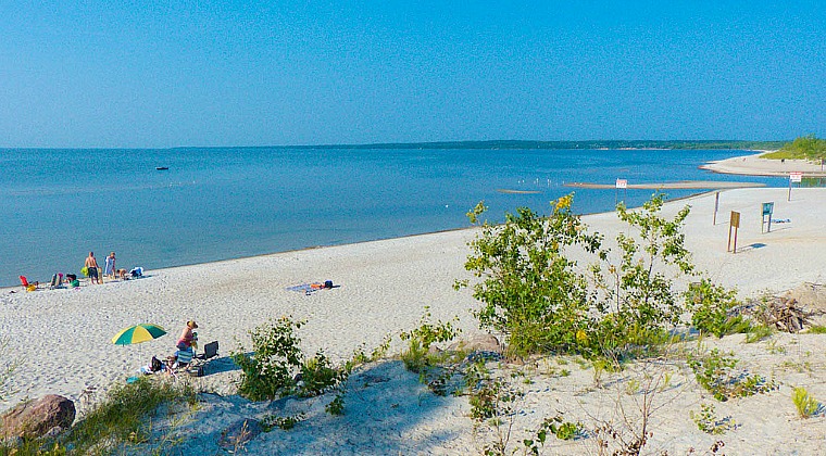
Lake Winnipeg is home to some of the best beaches in the country. Because of the many outdoor activities that can be pursued on the lake and its shores, Winnipeg is the perfect destination year-round. Numerous inns, B&Bs, hotels and campsites await visitors in various towns on the coast. Getting around the lake is easiest by car, since there is no public transportation system in the area. One of North America’s oldest continuous ethnic festivals is held here every August, called the Icelandic Festival of Manitoba.
Swimming, paddling and sailing are best in the southern basin of Lake Winnipeg. Kiteboarding, sailing and windsurfing are ideal in the Gimli, Grand Beach and Victoria area. Patricia Beach on the south is the closest beach to Winnipeg. Kayaking, hiking and cycling are ideal around the Hecla/Grindstone Provincial Park, which also has an 18-hole golf course. During the winter snow-kiteing is possible across the vast expanses of water and ice of Lake Winnipeg.
Trophy anglers can easily catch perch, walleye and northern pike on the east along the rivers. More than 800 commercial fisheries offer the opportunity to fish for walleye, goldeye, sauger and whitefish.